A major winter storm targeting the Washington region this weekend carries a threat more dangerous than its anticipated heavy snowfall: significant ice accumulation that could leave hundreds of thousands without power for days in life-threatening cold.
While snowfall projections of 6 to 14 inches across the District and surrounding suburbs have dominated forecasts, meteorologists are increasingly concerned about a transition from snow to freezing rain and sleet Sunday afternoon that could create hazardous conditions persisting well into next week.
“Power outages and tree damage are likely due to the ice,” the National Weather Service said Friday. A Winter Storm Warning was issued for the Washington area effective from 11 p.m. Saturday through 4 a.m. Monday. “Travel could be nearly impossible,” the NWS added.
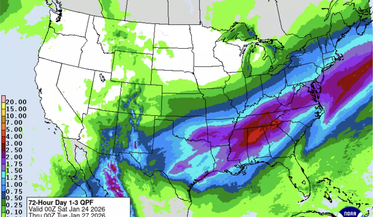
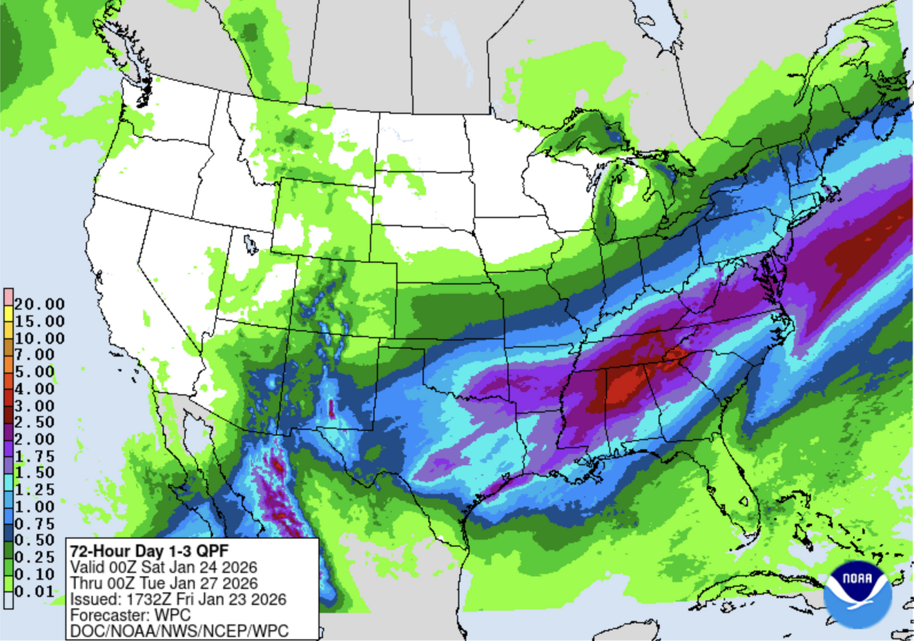
The weather setup involves a collision of Arctic air masses and low-pressure systems. A strong Arctic front pushed through Friday night, with high pressure moving southward from Central Canada ushering in bitterly cold temperatures. Meanwhile, low pressure over the Gulf Coast is expected to spawn a second system that will track northeastward along the Southeast and Mid-Atlantic Coast through Sunday, producing what the National Weather Service describes as a “significant, long-duration winter storm.”
The ice threat appears most severe from eastern Texas through the lower Mississippi Valley and into the Southeast, where Ice Storm Warnings have been issued. In these areas, AccuWeather warned Friday of “catastrophic” ice accumulations exceeding half an inch. The Weather Channel noted that the highest threat zones “may see even higher accumulations that could lead to extensive tree damage and numerous, widespread power outages.”
For the Washington region, the ice picture remains more uncertain but potentially significant, particularly for areas south and east of the District. The National Weather Service forecast calls for ice accumulations between one-tenth and two-tenths of an inch across much of the metro area, with higher amounts possible in southern Maryland and areas near the Chesapeake Bay.
“Significant icing is possible especially south of Highway 50,” the Weather Service stated Friday morning.
Local meteorologists emphasized that even modest ice accumulation atop several inches of snow could prove devastating. “There is potential for OVER 1/2 inch of sleet and freezing rain on top of OVER 6 inches of snow that can become too heavy for trees and power lines,” according to meteorologist Justin Berk, who runs Just In Weather, a regional weather blog. “Power Outages are very possible.”
The transition from snow to ice is expected to begin Sunday morning across southern areas and gradually push northward through the afternoon. However, forecasters caution that the exact placement of this transition zone, which could occur over just a few miles, will determine which neighborhoods face the worst impacts.
The ice threat is particularly concerning because of the prolonged Arctic cold that will follow. Temperatures are forecast to remain below freezing through at least next Saturday, with overnight lows potentially dipping into the single digits multiple times. This extended freeze means ice-coated trees and power lines will remain weighted down for days, and any fallen snow will not melt.
Energy companies have begun mobilizing additional crews to prepare for potential outages. Eleven states from Texas to New York have declared emergencies, with more than 177 million Americans under winter weather alerts as of Friday afternoon.
Forecasters urged residents to complete preparations Saturday, when conditions will be cold but dry, before the storm arrives Saturday night. They emphasized keeping emergency supplies including flashlights, extra batteries, food and water readily available, and warned that anyone requiring electrically powered medical equipment should have backup plans.
With ice accumulation likely and temperatures staying dangerously low for days, the weekend storm presents a compounding threat that could test the region’s infrastructure and residents’ preparedness in ways a simple snowstorm would not.
This article is written with the assistance of generative artificial intelligence based solely on Washington Times original reporting and wire services. For more information, please read our AI policy or contact Steve Fink, Director of Artificial Intelligence, at sfink@washingtontimes.com
The Washington Times AI Ethics Newsroom Committee can be reached at aispotlight@washingtontimes.com.