
Residents of Washington D.C. and surrounding areas of the DMV may want to rethink their upcoming weekend plans. Meteorologists are tracking a developing weather system that could bring anything from accumulating snowfall to just bone-chilling cold to the nation’s capital. Unfortunately, they won’t know which scenario will play out until later this week.
The storm is part of a larger weather pattern expected to affect more than 150 million Americans from Texas to New England starting Friday. But whether D.C. sees measurable snow or only Arctic air depends entirely on where the system, called Winter Storm Fern by The Weather Channel, decides to go.
Two weather systems on a collision course
Forecasters agree that a massive dome of Arctic air is settling over the Great Lakes region by week’s end, ready to push frigid temperatures south across the eastern United States. At the same time, a separate storm system is forming in the Southwest and heading east.
When that southern storm meets the Arctic air, the result will be winter precipitation. The question is where and what kind of winter precipitation should we expect? FOX 5 DC reports that the polar vortex, typically confined to the Arctic Circle, is shifting southward and funneling exceptionally cold air into the region.
“We have a perfect setup expected this weekend,” according to The Weather Channel, with cold air from the north and moisture from the south creating conditions ripe for winter weather.
The problem for forecasters, and for anyone trying to plan their weekend, is that a strong area of high pressure could act like a roadblock, steering the storm farther south than the Washington, D.C. area.
The forecast split: Snow or spine-tingling temperatures?
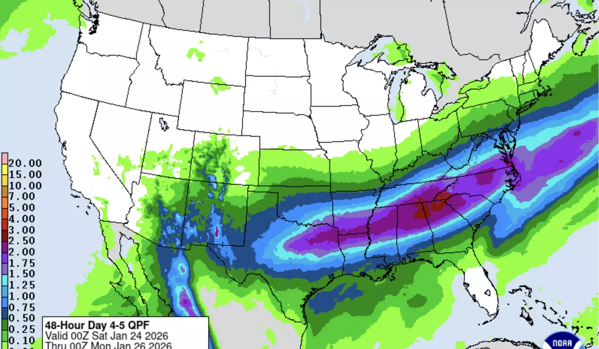
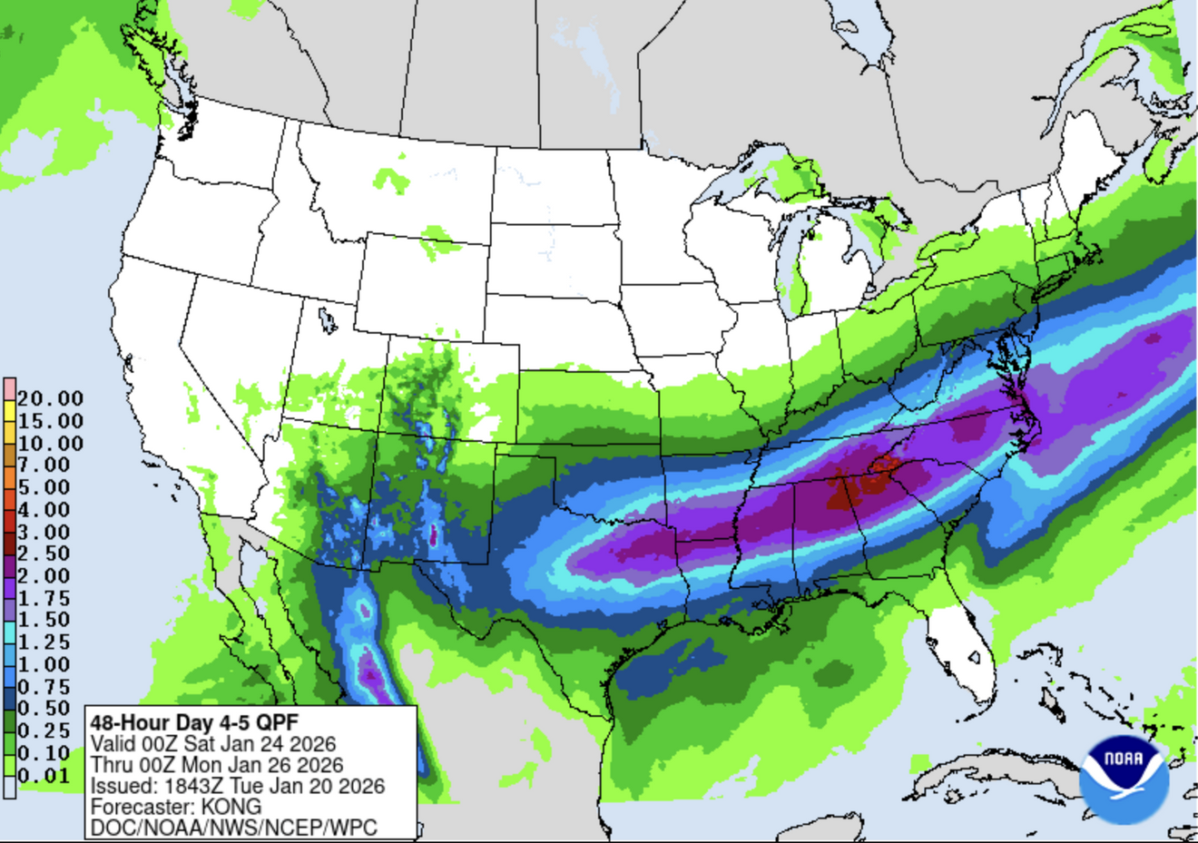
Weather models are telling different stories right now. The European model continues to show heavy snow for the D.C. metro area, possibly beginning late Saturday night and continuing into Sunday. The American GFS model, however, keeps the storm well to the south, delivering only minor snow to the region’s southern counties.
WUSA9 meteorologists outline the two possibilities. In the favorable scenario for snow lovers, the storm would center around North Carolina and southern Virginia, the sweet spot for Mid-Atlantic snowstorms. This would put D.C. in position for several inches of accumulation.
In the less snowy scenario, that high-pressure system successfully blocks the storm, pushing it farther south. D.C. would miss out on significant snow but still experience the Arctic plunge in temperatures.
What everyone seems to agrees on: Whether or not snow falls, dangerous cold is coming. Daytime temperatures may barely reach the mid-20s from Saturday through much of next week.
Widespread winter weather impacts from Texas to New England
While DC’s forecast remains uncertain, other parts of the country are bracing for definite winter weather impacts. Meteorologists say the storm will affect major cities including Dallas, Austin, Oklahoma City, Memphis, Nashville, Atlanta, Charlotte, and potentially reaching as far north as Philadelphia, New York City, and Boston.
One of the biggest concerns is ice, not snow. Areas from Texas to the Carolinas could see heavy ice accumulations, enough to snap tree branches and bring down power lines. The Weather Channel warns that widespread, long-lasting power outages are possible in these areas, made worse by the frigid temperatures that will follow.
Another area of concern: travel impacts. A storm of this size and potential could lead to flight delays and cancellations across the country. “Some areas in the southern part of the nation could experience their worst snow or ice storm in years,” notes AccuWeather. “In portions of the Northeast, this could end up being the biggest storm of the winter so far, aside from localized lake-effect.”
For the northern tier of states, the cold itself is the main story. Low temperatures from the Dakotas to Michigan could drop 15 to 25 degrees below zero, with wind chills possibly reaching 35 to 45 degrees below zero. The National Weather Service in Duluth is describing this as “life threatening cold.”
Even in typically milder areas, this could be the coldest air of the winter season so far, potentially surpassing the December cold snap many regions experienced.
What Washington, D.C. residents should keep in mind
If snow does develop for the Washington, D.C area, WUSA forecasters say it would be a “pure snow event,” no mixing with sleet or freezing rain. The most likely window is late Saturday afternoon or evening through Sunday, though this timing could change.
The National Weather Service may issue winter weather watches, advisories, or warnings as the forecast becomes clearer. A watch means significant winter weather is possible within 48 hours. A warning means it’s happening or about to happen.
For now, 7News meteorologists recommend keeping weekend travel plans flexible but avoiding panic. “No panic prep needed, no need to start clearing the shelves for milk and toilet paper at local markets,” they advise.
The forecast should come into sharper focus over the next few days as the storm system begins to develop and weather models converge on a solution. Until then, D.C. residents are in a familiar holding pattern: watching, waiting, and wondering whether to dig out the snow shovel or just the heavy coat. In the meantime, coming up with some alternatives to your weekend plans might not be the worst idea.
This article is written with the assistance of generative artificial intelligence based solely on Washington Times original reporting and wire services. For more information, please read our AI policy or contact Steve Fink, Director of Artificial Intelligence, at sfink@washingtontimes.com
The Washington Times AI Ethics Newsroom Committee can be reached at aispotlight@washingtontimes.com.