

A potent winter storm expected to sweep from the South into the Mid-Atlantic and Northeast could bring significant snow and hazardous travel to the District of Columbia this weekend, as a fresh surge of Arctic air drives temperatures sharply lower.
Forecasters caution that key details, including exact snowfall totals and any sleet or freezing rain, remain uncertain several days out. But confidence is increasing that the region will see impactful winter weather Saturday into Sunday, with bitter cold lingering into next week.
A cold pattern sets in before the storm arrives
The District region is moving into a stretch of reinforcing cold fronts that will steadily reload frigid air through the weekend, according to Washington-area forecasts. Wednesday began with single-digit wind chills in the region, before a brief break Thursday with highs rising into the 50s. That warmth, unfortunately, won’t last.
By late Friday into Saturday, forecasters expect a stronger push of Arctic air to settle in behind the storm setup, keeping temperatures well below freezing and increasing the risk of icy roads and long-lasting snow cover.
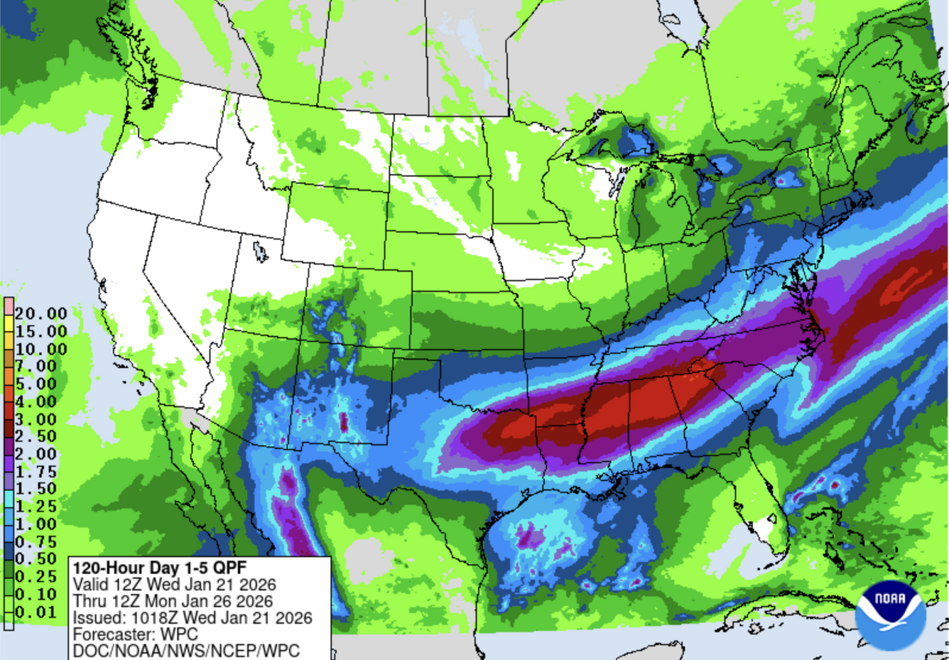
A sprawling storm from Texas to the Northeast
The Weather Channel says the system, dubbed “Winter Storm Fern,” could affect more than 180 million people nationwide with snow and/or ice from Friday through Monday. The heaviest snow in the Mid-Atlantic is expected Saturday night into Sunday, a timing that would make travel “difficult to impossible” in spots along and near the I-95 corridor.
AccuWeather has also warned of a high-impact storm stretching across more than two dozen states, with the South facing the greatest risk for crippling ice. AccuWeather Chief Meteorologist Jonathan Porter said “potentially hundreds of thousands of people may go without electricity and heat for days,” and warned that widespread disruptions could extend into next week because of the cold.
What the District and surrounding regions can expect
For the District, the National Weather Service has signaled increasing concern. “Confidence is high for a significant winter storm for the region Saturday into Sunday,” the agency wrote on social media. “Significant travel delays, closures, and threats to life and property are becoming increasingly likely. Now is the time to plan to minimize impact on you and your family.”
Timing forecasts vary by outlet, but the consensus is that the region’s most disruptive period is likely late Saturday through Sunday.
- Saturday: Much of the day may remain dry, with clouds building as the storm approaches. Because Arctic air is typically very dry, some snow may initially evaporate before it reaches the ground, a factor that could delay meaningful accumulation until later Saturday night in parts of the region.
- Saturday night into Sunday: The Weather Channel’s forecast window includes snow spreading into the District and Baltimore Saturday night and continuing Sunday.
- Sunday intensity: CBS Baltimore meteorologist Steven Sosna said the “brunt” of the storm for Maryland is expected Sunday, with “1 to 2 inch per hour rates possible” in spots Sunday morning. Mr. Sosna also noted indications that snow could mix with sleet or freezing rain, especially from Baltimore and points south and east, a change that could reduce snow totals while keeping travel dangerous.
Because the storm track may still shift, outlets caution against locking onto a single snowfall number. AccuWeather said some locations on the colder side of the storm could see 6 to 12 inches of snow or more where mixing is limited, while noting that totals could vary with the storm’s final path. At this point, we are still too far out to determine amounts or the certainty of the storm track.
Cold lingers, keeping impacts around
Even after the storm moves well beyond the District, forecasters expect cold air to remain entrenched, slowing melting and allowing untreated roads and sidewalks to stay icy. Temperatures will likely remain below freezing for an extended period after the storm, making it challenging for snow and ice to melt next week. Secondary roads and sidewalks could remain hazardous if not treated.
The National Weather Service, also warns that the prolonged nature of this arctic outbreak could lead to pipe bursts, as well as increase the risk for hypothermia.
Air travel could also be affected well beyond the immediate storm window. Mr. Porter said AccuWeather expects “more than 4,000 flight cancellations” nationwide this weekend, with major East Coast hubs at risk for significant delays if snow and ice intensify.
This article is written with the assistance of generative artificial intelligence based solely on Washington Times original reporting and wire services. For more information, please read our AI policy or contact Steve Fink, Director of Artificial Intelligence, at sfink@washingtontimes.com
The Washington Times AI Ethics Newsroom Committee can be reached at aispotlight@washingtontimes.com.