
The winter storm expected to bring snow and ice to the District will likely have impacts that extend beyond just a weekend inconvenience. Forecasters warn that bitter cold could grip the area through next week, with frigid temperatures threatening to keep snow and ice locked in place long after the storm passes.
The National Weather Service said Wednesday that a prolonged Arctic outbreak could bring hazardous cold to much of the eastern United States, potentially extending through Feb. 3. About 230 million Americans are expected to face extreme cold below 20 degrees, with 85 million under weather warnings or advisories.
“Talks of snow may be exciting, but dangerously cold temperatures bring even more risk this weekend,” the weather service said in a social media post. Wind chills of minus 50 degrees are forecast for the Plains, with sub-zero wind chills reaching as far southeast as the Mid-Atlantic states.
While attention has focused on the heavy snowfall expected to affect parts of the East from Friday through Monday, meteorologists say the more significant threat may be what comes after: an extended deep freeze that will prevent melting and could leave side streets impassable, schools closed and neighborhoods struggling with power outages for days.
Emma Belscher, an AccuWeather meteorologist, predicted some locations will be slow to rise above freezing even after snow and ice subsides across the Southeast. “This will prolong impacts as snow and ice will not be quick to melt and can easily refreeze overnight,” Ms. Belscher said.
The prolonged nature of the cold outbreak sets this event apart from typical winter storms that dump snow but give way to milder temperatures within days, allowing for cleanup and recovery.
Steven Sosna, a meteorologist with CBS Baltimore, said temperatures in the Baltimore-Maryland area are forecast to stay below freezing for the next 10 days, creating particularly extended impacts for the state.
“This means that side and secondary roads along with some neighborhood sidewalks may remain treacherous if left untreated through the end of next week,” Mr. Sosna said. “Widespread school closures are likely Monday and potentially through the middle of next week if the storm reaches its full potential.”
The National Weather Service cautioned that the extended freeze poses risks beyond travel disruptions. “The prolonged nature of this arctic outbreak could lead to pipe bursts, as well as increasing the risk for hypothermia,” the weather service said in an update. “Additionally, any power outages caused by a winter storm this weekend could prolong and compound this risk.”
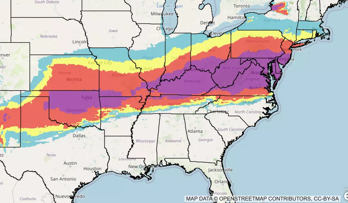
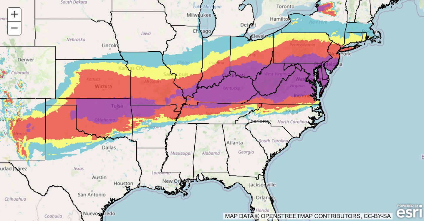
Forecasters emphasized significant uncertainty remains about exact snowfall amounts as the storm system takes shape. Weather model guidance shows a wide range of possible accumulations, with the storm’s precise track and intensity still unclear.
Mr. Sosna said there is a high likelihood of 6 or more inches of snow across Maryland, with the potential for double-digit snowfall totals in areas north and west of the Baltimore Beltway that receive all snow without any mixing of sleet or freezing rain.
The weather service noted in its national forecast that heavy snow accumulations are likely in a large swath from the Southern Rockies and Plains eastward to the Mid-Atlantic and into New England, with local areas potentially seeing maxima above 12 inches.
Single-digit and teen-degree temperatures across the area into early next week will make snow removal difficult. Even with sunshine returning after the storm departs, temperatures are expected to remain so cold that plowed snow will struggle to melt during daylight hours. Overnight refreezing will create black ice on treated roads and leave untreated surfaces dangerous.
“Once the snow and ice is on the ground, it will likely not go anywhere for the foreseeable future,” Mr. Sosna said.
Jonathan Porter, AccuWeather’s chief meteorologist, warned that the combination of heavy snow and ice followed by persistent cold could overwhelm utility crews. “Potentially hundreds of thousands of people may go without electricity and heat for days,” Mr. Porter said.
The extended cold will also complicate recovery efforts. Road salt and chemicals become less effective as temperatures drop below 20 degrees. With highs forecast to remain in the teens and low 20s through much of next week, clearing secondary roads and neighborhood streets could prove exceptionally difficult.
Schools and child-care centers could face closures lasting well beyond the typical snow day. With temperatures staying below freezing and many neighborhood streets likely to remain snow-covered or icy, administrators may keep buildings closed through the middle of next week or longer.
Forecasters believe widespread record low temperatures are possible across the eastern two-thirds of the country.
Residents should complete storm preparations before Friday and plan for disruptions lasting beyond the weekend. Those who lose power could face dangerous conditions as overnight lows dip into the single digits with wind chills potentially reaching below zero in outlying areas.
The weather service urged residents to check on neighbors during the cold period and ensure adequate heating. Officials also warned residents to ensure pets and animals have protection from the cold.
“These wind chills will pose a life-threatening risk of hypothermia and frostbite to exposed skin,” the NWS’ Weather Prediction Center said, per USA Today. “Prepare and have a plan to stay warm.”
This article is written with the assistance of generative artificial intelligence based solely on Washington Times original reporting and wire services. For more information, please read our AI policy or contact Steve Fink, Director of Artificial Intelligence, at sfink@washingtontimes.com
The Washington Times AI Ethics Newsroom Committee can be reached at aispotlight@washingtontimes.com.