The Washington region is bracing for a rare high-end severe-weather threat Monday, with tornado watches in effect, damaging winds possible and temperatures expected to tumble sharply — dropping as much as 40 to 50 degrees — after the storms move through.
Forecasters warned that the most dangerous period would likely come late Monday afternoon into the evening commute, when a fast-moving line of storms could bring damaging wind gusts and isolated tornadoes to the I-95 corridor.
The watch and the risk level
The National Weather Service’s Storm Prediction Center issued Tornado Watch 67 at 10:50 a.m. Monday, placing the watch in effect until 7 p.m. EDT. The watch covers a wide swath of Virginia counties and independent cities, including Arlington, Fairfax, Loudoun, Prince William, Stafford, Spotsylvania, Fauquier and Alexandria, according to the official NWS watch bulletin. It also covers the District of Columbia and portions of Maryland.

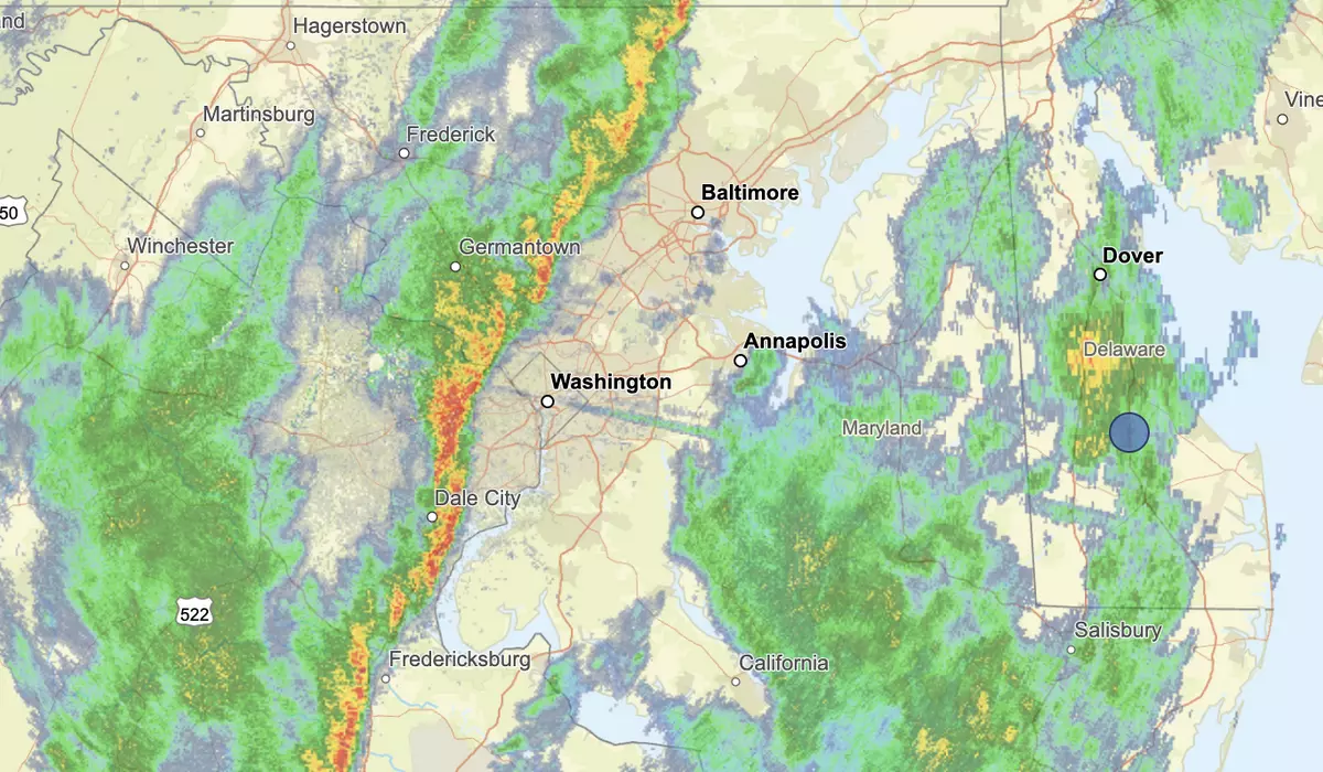
National Weather Service Radar on Monday …
more >
The NWS said in a Hazardous Weather Outlook issued at 12:35 p.m. that “severe thunderstorms capable of producing damaging winds and tornadoes are likely this afternoon and evening,” with the potential for wind gusts of 70 to 80 mph “as well as an isolated stronger tornado.” The agency said those threats were highest for areas along and east of Interstate 81.
Much of the area is under a moderate risk for severe storms at a level 4 out of 5. That’s a designation rarely issued for the D.C. region, according to the Storm Prediction Center.
WTOP Meteorologist Mike Stinneford explained the significance of that rating before the storms arrived. “It basically tells us that the models had a pretty good idea that we were going to see an outbreak of severe weather on Monday afternoon,” Mr. Stinneford said. “I do believe this is going to affect the metro area right around the first part of the rush hour on Monday afternoon. This squall line may produce damaging winds, large hail and even some tornadoes.”
AccuWeather meteorologists placed the D.C. metro area within a high-risk corridor for the storm, which it dubbed the “Triple-Threat March Megastorm,” part of a broader severe weather outbreak stretching across more than a dozen states.
The timing
Forecasters said the threat would unfold in multiple rounds, with conditions becoming more dangerous as the day wore on. The Washington Post reported that the first roundfin the Mid-Atlantic was expected between 10 a.m. and 3 p.m., though it was forecast to be more scattered, with at least some tornado risk during that period. The second round — the main event — was expected in the evening, “probably from 4 p.m. to 8 p.m.,” before pushing offshore after sunset.
NBC4 Washington’s Storm Team4 gave a similar but slightly broader warning window, saying the main threat for the D.C. region was 3 p.m. through 9 p.m. Meteorologist Chuck Bell wrote that the cold front was expected to reach the I-81 corridor around 6 p.m., the I-95 corridor between 7 p.m. and 8 p.m., and Southern Maryland between 9 p.m. and 10 p.m. That timeline is especially important for commuters, because Bell warned that much of the threat would unfold during the afternoon and evening drive, adding that anyone who could get home before 4 p.m. should consider doing so.
FOX 5 DC also described two rounds of storms, placing the most active overall window between 11 a.m. and 9 p.m. In its breakdown, the station said a midday round could bring blinding downpours, strong wind gusts and a brief tornado threat, followed by afternoon periods of heavy rain and gusty winds. A second line was then expected to form along the cold front during the evening, bringing another burst of damaging winds before conditions improved later at night.
WTOP’s coverage sharpened the local urgency, reporting that another band of severe weather was forecast to hit the region during the evening commute. The outlet also cited National Weather Service messaging that storms would move “very rapidly” and that residents should take action when warnings are issued rather than wait to see or hear the storm themselves.
Wind, tornado and flooding hazards
AccuWeather Chief Meteorologist Jon Porter named the D.C. area specifically in his assessment of the tornado threat. “A few tornadoes, including the possibility of an especially intense tornado, cannot be ruled out, especially from near the Baltimore and Washington, D.C., metro areas through Virginia and into North Carolina,” Mr. Porter said in AccuWeather’s forecast.
The NWS Hazardous Weather Outlook warned directly that the threat was not limited to thunderstorm winds. An isolated stronger tornado was also possible for areas along and east of Interstate 81. The agency activated the SKYWARN amateur radio network for Tornado Watch 67, with weather spotters asked to relay any severe storm impacts to the NWS office in Sterling, Va.
AccuWeather Senior Meteorologist Alex Sosnowski warned of the flooding risk alongside the wind and tornado threats. “The rainfall in this zone can easily reach 1 to 2 inches per hour,” Mr. Sosnowski said. “Even a brief period of intense rain such as this will lead to urban flooding problems along the Interstate 95 corridor.”
The temperature collapse
The storms are arriving on the warm side of the system, with afternoon highs expected to reach the upper 60s to low 70s before the cold front barrels through.
That is what makes the post-storm cooldown so striking. NBC4 warned of “another 40- to 50-degree plunge Monday night,” saying temperatures would fall to below freezing by Tuesday morning. Monday night lows are expected to touch somewhere beween 25 to 30 degrees, with strong northwest winds behind the front.
The colder air is not just a one-night snap. WTOP said Tuesday would feel “much more like winter returning to the region,” with highs struggling to reach the upper 30s to mid-40s and northwest gusts making it feel closer to the 20s and 30s. NBC4 projected Tuesday highs of only 36 to 42 degrees and said almost the entire area would be below freezing Tuesday, Wednesday and Thursday mornings.
That rapid drop also explains the back-edge snow mention, but it should stay modest. WTOP forecast “wet snowflakes possible” Monday night, and FOX 5 DC said a few wet snowflakes could mix in as colder air rushes in behind the storms. That is enough to support a brief mention, but not a stronger suggestion of accumulating snow in Washington.
Commute and school impacts
Forecasters are urging anyone able to leave work and be home before 4 p.m. to take that option. For those caught on the roads during storms, experts say motorists should never stop under an overpass. Instead, it’s best to take the nearest exit and find a sturdy building for shelter if storms were approaching. “Just about anywhere is safer than being in your car,” NBC4 reported.
School systems across the region moved to get students home before conditions deteriorated. WMAR-2 News reported that Anne Arundel County Public Schools closed two hours early, citing the forecast for severe weather including potential tornadoes, with all afternoon programs, field trips and extracurricular activities canceled. Baltimore City and Carroll County public schools each released two hours early. Baltimore County and Howard County public schools ordered three-hour early closures. Harford County Public Schools also dismissed three hours early. Cecil County Public Schools sent secondary students home at 11 a.m. and elementary students at noon.
In Northern Virginia, Fairfax County Public Schools and Arlington Public Schools both issued early dismissals ahead of the storm, canceling after-school activities and extended care programs, WTOP’s closings page reported. A full list of closings and delays is available there.
This article was constructed with the assistance of artificial intelligence and published by a member of The Washington Times’ AI News Desk team. The contents of this report are based solely on The Washington Times’ original reporting, wire services, and/or other sources cited within the report. For more information, please read our AI policy AI policy or contact Steve Fink, Director of Artificial Intelligence, at sfink@washingtontimes.com
The Washington Times AI Ethics Newsroom Committee can be reached at aispotlight@washingtontimes.com.